Hurricanes Helene and Milton, which have ravaged parts of the southeastern United States, bookend a remarkably busy period of tropical storms. Within two weeks, five hurricanes formed, a number approaching the typical Atlantic hurricane count for an entire year. These storms were particularly potent, rapidly gaining strength. Yet, in early September, a time usually marked by peak hurricane activity, there were curiously few storms. This begs the question: how unusual has this hurricane season been, and what factors are driving it?
The season began ominously. On July 2nd, Hurricane Beryl became the earliest Category 5 hurricane to form in the Atlantic since record-keeping began in 1920. Just weeks earlier in May, US scientists warned of an “extraordinary” 2024 hurricane season, predicting that exceptionally warm Atlantic temperatures, coupled with shifts in regional weather patterns, would create ideal conditions for hurricane formation.
So far, with seven weeks remaining in the official season, there have been nine hurricanes—two more than the Atlantic typically experiences. However, the overall number of tropical storms, which includes hurricanes and weaker storms, has remained around average, falling short of initial predictions. After Beryl weakened, there were only four named storms and no major hurricanes until Helene formed on September 24th. This occurred despite the warm waters in the tropical Atlantic, typically conducive to storm growth. Analysis of data from the European climate service reveals that sea surface temperatures in the Main Development Region for hurricanes—spanning the west coast of Africa to the Caribbean—have been approximately 1°C above the 1991-2020 average. Atlantic temperatures have consistently risen over the past decade, largely attributed to climate change and a natural weather pattern known as the Atlantic Multidecadal Oscillation.
While warm waters are crucial, hurricane formation is a complex process involving multiple factors. These other conditions, however, were not conducive to storm development. Christina Patricola, associate professor at Iowa State University, explains, “The challenge [for forecasting] is that other factors can change quickly, on the timescale of days to weeks, and can work with or against the influence of sea surface temperatures.”
Researchers are still investigating the reasons behind this atypical season, but several factors likely contributed. A shift in the West African monsoon and an abundance of Saharan dust created unfavorable atmospheric conditions, hindering storm development. Nevertheless, scientists continued to emphasize the exceptionally warm ocean waters, highlighting the potential for intense hurricanes throughout the remainder of the season.
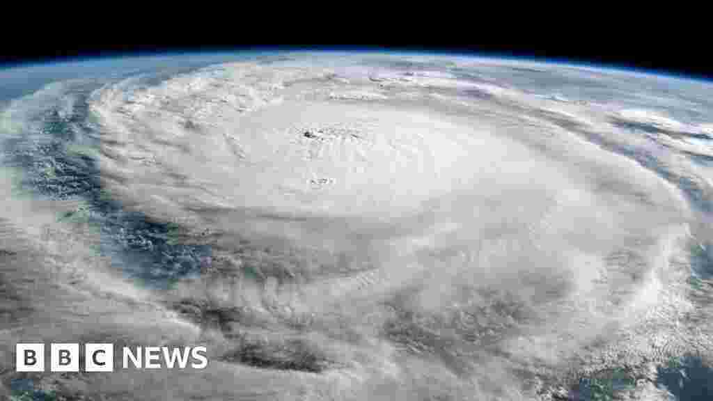
Their warnings proved accurate. Starting with Helene, six tropical Atlantic storms emerged in rapid succession, fueled by very warm waters and now favorable atmospheric conditions. Five of these storms escalated to hurricane status, with four experiencing "rapid intensification," a phenomenon characterized by a rapid increase in maximum sustained wind speeds by at least 30 knots (35 mph; 56 km/h) within 24 hours. Historical data suggests that only around one in four hurricanes undergo rapid intensification on average. This rapid intensification poses significant danger as communities have less time to prepare for the intensifying storm.
Hurricane Milton experienced an unprecedented increase in wind speeds, exceeding 90 mph within 24 hours, one of the fastest such cases of intensification on record, according to BBC analysis of data from the National Hurricane Center.
Scientists from the World Weather Attribution group have concluded that the winds and rainfall associated with Helene and Milton were exacerbated by climate change. “One thing this hurricane season is illustrating clearly is that the impacts of climate change are here now,” explains Andra Garner from Rowan University in the US. “Storms like Beryl, Helene, and Milton all strengthened from fairly weak hurricanes into major hurricanes within 12 hours or less, as they travelled over unnaturally warm ocean waters.”
Milton also took an unusual, though not unprecedented, storm path, tracking eastward through the Gulf of Mexico, where waters have been exceptionally warm. "It is very rare to see a [category] five hurricane appearing in Gulf of Mexico," says Xiangbo Feng, research scientist in tropical cyclones at the University of Reading.
Warmer oceans increase the likelihood of stronger hurricanes and rapid intensification, as storms can absorb more energy, potentially leading to higher wind speeds.
US forecasters are currently monitoring an area of thunderstorms over the Cabo Verde Islands off the west coast of Africa. This has the potential to develop into another tropical storm within the next few days, although uncertainty remains.
Concerning the remainder of the season, high sea surface temperatures continue to favor further storm formation. There is also a likely development of the natural La Niña weather phenomenon in the Pacific, which often promotes Atlantic hurricane formation by influencing wind patterns. However, further activity hinges on favorable atmospheric conditions, which are difficult to predict.
Regardless of the future course of the season, this year has already highlighted the influence of climate change on the increasing likelihood of powerful hurricanes. This trend is projected to continue as global temperatures rise.
“Hurricanes occur naturally, and in some parts of the world they are regarded as part of life,” explains Kevin Trenberth, a distinguished scholar at the National Center for Atmospheric Research in Boulder, Colorado, USA. “But human-caused climate change is supercharging them and exacerbating the risk of major damage.”
How unusual has this hurricane season been?
Hurricanes Helene and Milton have bookended a particularly stormy period. What's behind it?