
Severe Weather Threatens Parts of the U.S.
According to the National Weather Service, a powerful storm system is expected to impact several states in the Central United States before moving eastward. The affected states include Indiana, Illinois, Missouri, Oklahoma, and Texas. The storm system has the potential to unleash tornadoes, thunderstorms, and large hail. Here's what you need to know about the forecast:
Tornadoes: There is a possibility of tornadoes across parts of the Central United States on Monday.
Thunderstorms: On Tuesday, thunderstorms are expected to spread into the Appalachians and the Mid-Atlantic region.
Forecast Details
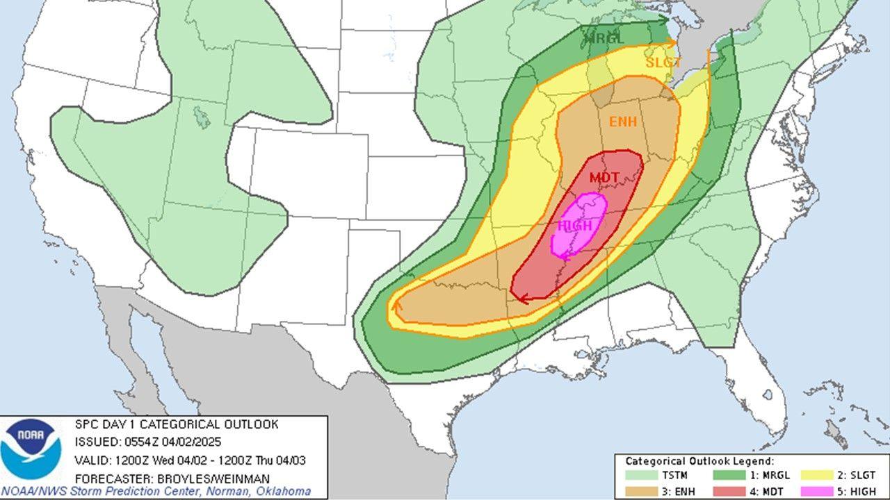
The Storm Prediction Center of the National Weather Service has identified large sections of Indiana, Illinois, Missouri, Oklahoma, and Texas as being at risk of damage from strong winds and hail greater than two inches in diameter. The areas most at risk on Monday include central and eastern Oklahoma, far southeast Kansas, and central Missouri. It's important to note that this comes just weeks after tornadoes ravaged Indiana, Kentucky, and Ohio, resulting in three fatalities.
Approximately eight million people live within areas with an enhanced risk of severe weather, which is the third level on a five-level scale used by the Weather Service. Some of the cities facing an enhanced risk on Monday include Tulsa, Oklahoma; St. Louis and Springfield, Missouri; and Evansville, Illinois.
The storm system is expected to strengthen as it moves eastward into the Upper Ohio Valley on Monday night, bringing heavy rainfall and the potential for flash flooding. On Tuesday, heavy showers, winds, and thunderstorms are projected to spread into the Appalachians and the Mid-Atlantic region.
Flood watches have been issued for parts of Indiana, Kentucky, Ohio, West Virginia, and western Maryland, extending through Tuesday evening. Rainfall totals are anticipated to exceed two inches in many areas, with localized amounts of up to five inches.
Forecasters are closely monitoring the storm system as two separate low-pressure centers over the Great Lakes and the Mid-Atlantic are expected to converge by the middle of the week. This convergence could result in an early April nor'easter off the New England coast by Thursday morning. The nor'easter has the potential to bring six inches or more of snow to the Great Lakes and the Northeast.
About the Author
The article was written by Orlando Mayorquín, a breaking news reporter based in New York. He is also a member of the 2023-24 Times Fellowship class, a program for early-career journalists.
Additional Weather Coverage
If you're interested in exploring more weather-related topics, The New York Times offers a range of articles to help you stay informed and prepared. Here are a few suggested articles:
- Preparing Your House for the Cold: Learn about steps you can take to prepare for bitter cold, strong winds, and other severe winter conditions at home.
- Wind Chill Index: Understand how meteorologists measure the feeling of cold, even when the ambient temperature remains the same.
- On the Road: Discover safety tips for drivers caught in a snowstorm, including how to stay warm and collected when stranded.
- Is It Safe to Go Outside?: Find guidance on determining when it's safe to venture outdoors, considering factors such as heat, flooding, and wildfire smoke.
- Climate Change: Gain insights into the causes of global warming and explore potential solutions to address this pressing issue.
- Evacuating Pets: Learn how to plan ahead and protect your pets when faced with a disaster.
- Extreme Weather Maps: Keep track of the possibility of extreme weather in the specific locations that matter to you.