A powerful winter storm is currently hammering parts of the Central Plains with blizzard conditions and is expected to bring heavy snowfall from Colorado to Minnesota until Tuesday. This storm poses a threat of widespread power outages and dangerous road conditions. By Tuesday, the storm will move across the Midwest and Great Lakes before shifting to the Northeast. As of Monday, nearly 160,000 homes and businesses in the Northeast are still without power following the weekend snowfall.
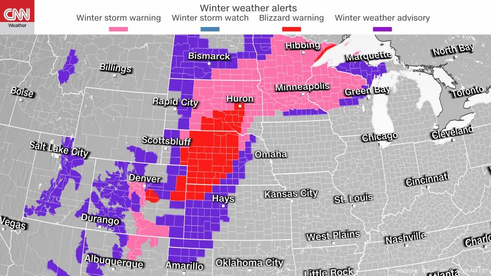
Blizzard warnings are in effect for northern Colorado, Kansas, parts of Minnesota, Nebraska, and South Dakota on Monday. The National Weather Service predicts snowfall ranging from 2 to 10 inches in these areas, with some places potentially receiving over a foot of snow. This storm follows back-to-back winter storms that have already dumped significant amounts of snow on some cities, with the current storm expected to have longer-lasting impacts.
The National Weather Service has issued warnings that travel may become nearly impossible in certain areas as the storm progresses through the Plains and Upper Midwest, creating icy roads and whiteout conditions. Freezing rain and sleet have already caused slick road conditions in parts of Nebraska on Sunday night, and more severe whiteout conditions are expected as rain transitions to blowing snow. Widespread power outages are also a concern as strong winds and heavy, wet snow could damage power lines and trees.
Winter storm warnings stretch from New Mexico to Wisconsin and the Dakotas, with potential snowfall totals of 4 to 12 inches. Last week, a storm brought significant snowfall from the northern Plains to the Northeast, with some states, including Maine, New Hampshire, and Vermont, receiving over two feet of snow. As of late Sunday night, approximately 160,000 homes and businesses in the Northeast were still without power, with the majority of outages occurring in Maine.
The impact of the storm on power lines in Maine has been significant, with Central Maine Power responding to over 700 emergency calls on Sunday, including reports of blocked roads and downed lines. While power has been restored to over 50% of customers impacted by the storm, restoration efforts in heavily affected coastal areas may continue until Wednesday.
In addition to the winter storm, a rare geomagnetic storm occurred, increasing the likelihood of seeing the Aurora Borealis, or Northern Lights, in parts of the Pacific Northwest, Northern Plains, Great Lakes, and interior Northeast overnight Sunday. This geomagnetic storm, caused by a strong surge of solar wind known as a "coronal mass ejection," may result in interruptions on Earth, such as radio frequency blackouts and GPS problems.
The Aurora Borealis is expected to be highly active across Alaska, allowing the lights to be visible (weather permitting) from Utqiaġvik to as far south as Kodiak and King Salmon. Some cities north of the viewing line include Seattle, Chicago, Minneapolis, Detroit, Milwaukee, Buffalo, and Portland. This severe geomagnetic storm was initially rated a level G4 out of 5 on Sunday afternoon but has since dropped to a level G3 out of 5 for early Monday morning.
Sources: CNN, US Geological Survey, National Weather Service
Snowstorm across Plains and Midwest brings heavy snow and blizzard conditions
A powerful winter storm is pummeling parts of the Central Plains with blizzard conditions and is set to drop a blanket of snow from Colorado to Minnesota through Tuesday, threatening widespread power outages and treacherous road conditions.